Orenstein and the Garbal team—roughly a dozen local data analysts, project managers, digital finance experts, and tele-agents with degrees in livestock management and applied agriculture—have designed different tools for herders’ needs. For example, they’ve offered ways to connect with veterinarians, compare market prices for animal feed, and use satellite data to find seasonal migration corridors and track brushfires. Crucially, the team has also engaged directly with pastoralist organizations, training and equipping herders to send back field data about vegetation quality in different zones—a piece of critical information that is undetectable via satellite.

Orenstein himself went into the field as often as he could to hold focus groups with herders and ensure that the way information was delivered would be adapted to their epistemic culture. “Instead of asking them, ‘Do you need rainfall information?’ I would say, ‘What kind of information do you need? And how do you measure it?’” he recalls. “Otherwise, the system would tell them to expect 25 millimeters of rain. Math is not how they measure. So instead, I would hold consultations on pond fullness, for example, and define rain strength in those terms—terms they can use.”
Samba Ba, the Senegalese herder, notes how effective this work has been in bridging the gulf between what tech had promised and what he and his peers actually needed. “Orenstein would help us forecast in September what the vegetation would be like the following year, so we could plan the next seasonal migration,” he says. “He came to us in the field, took into account our customs, habits, and knowledge, and used technology to give us a clearer idea of the grazing situation.”
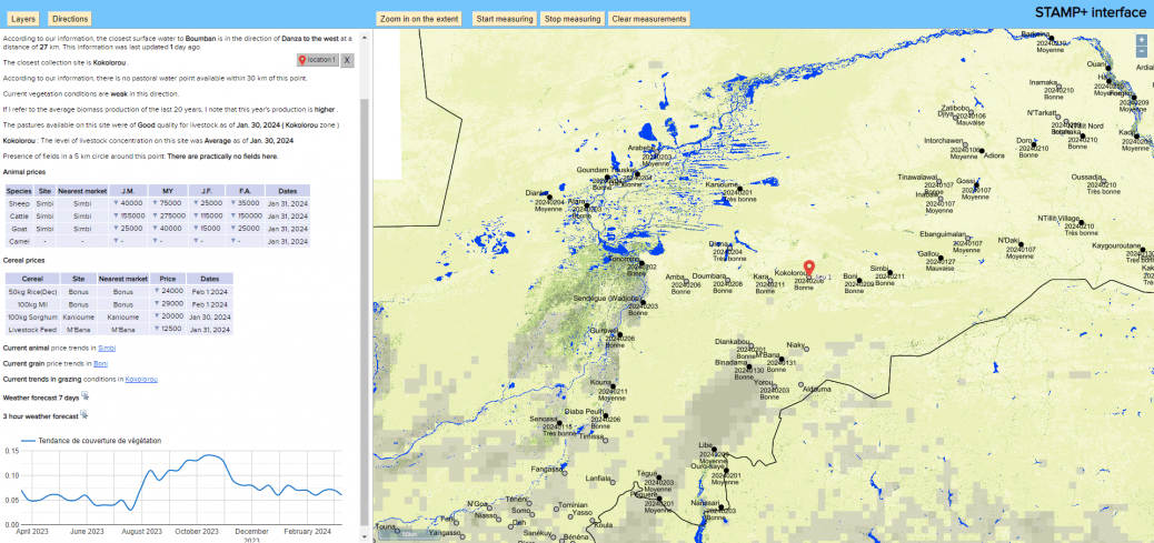
Still, the most popular Garbal service has been its weather forecasting for rural zones. Previously, reliable information was severely lacking, in part because there were not enough ground stations and in part because satellite data was available only for urban areas. (Mali, for instance, has just 13 active weather stations, compared with 200 in Germany—a country one-third its size.)
Orenstein came up with a way to make rural forecasts more readily available. “We had the coordinates for every village in Burkina Faso. Why couldn’t we just plug those into an API?” he remembers thinking, referring to an application programming interface, a kind of intermediary that allows applications to interact with one another. “Suddenly, we were getting weather forecasts for places that weren’t listed anywhere.”
The API has enabled Garbal tele-agents to click on remote pastoral zones on a map and receive tables showing weekly, daily, and hourly forecasts that are updated with fresh satellite data every three hours. Honoré Zidouemba, the project manager for the Ouagadougou call center, estimates that during the rainy season, his center receives 2,000 to 3,000 calls a day about the weather. “Herders and farmers used to derive information from natural cues,” he says, “but with climate change, those are more and more perturbed.”
It’s simple and inexpensive—costing under $100 a month to use—but of all the team’s technological innovations, the API has made the biggest impact. And it’s a far cry from the kinds of higher-tech applications NGOs and development organizations have been promoting.
Since 2015, the World Bank has committed half a billion dollars to a two-phase project to support Sahelian herders’ “resilience” through strategies that include developing technological tools to map pastoral infrastructure. A senior humanitarian-agency staffer working with herders and technology, who requested anonymity to speak frankly, says the resulting databases have not been shared with herders; he calls the approach, which is geared more toward informing institutions than informing herders, “very technocratic.” (The World Bank did not respond to a request for comment.)


Recent Comments